Information on technical characteristics, the delivery set, the country of manufacture and the appearance of the goods is for reference only and is based on the latest information available at the time of publications.
Additional Information
Features
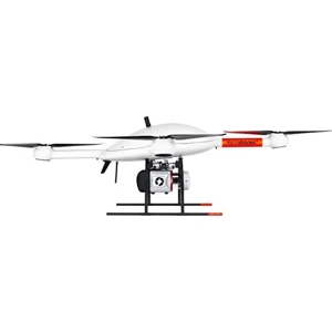
The most powerful drone LIDAR system ever with the capability to collect vertical features via a wider field of view
Go extreme with the most powerful laser scanner extend your data collection reach from high above or collect extreme point density when flying closer to the ground
Microdrones’ mdLiDAR3000LR uses the lifting power resilience and efficiency of the Microdrones aircraft platform to carry a perfectly integrated Riegl VUX 1UAV
The result? You can quickly acquire high density and accurate LiDAR data from high above your subject in the field and efficiently turn it into a 3D pointcloud back at the office or on your laptop
Ratings & Reviews
Be the first to write a review
Write a review
Company Information
Name
Zan Modern Company
About Us
Information on technical characteristics, the delivery set, the country of manufacture and the appearance of the goods is for reference only and is based on the latest information available at the time of publication.